
For Sale at the MATC On-line Store
Book and 7 maps:
$24.00 MATC Members (20% discount)
$30.00 Non-members
Book with no maps:
$12.00 MATC Members. (20% discount)
$15.00 Non-members
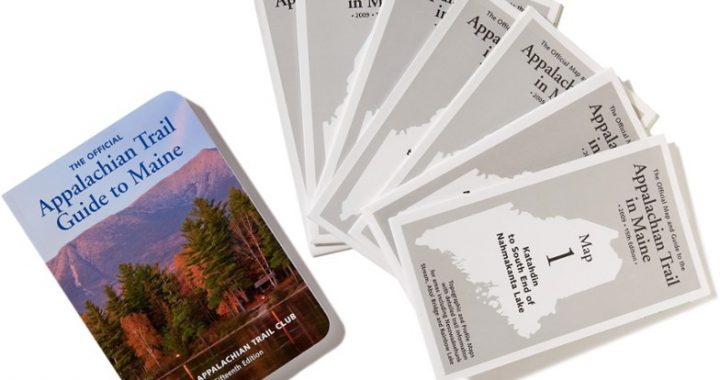
The Maine edition covers 282 miles from Katahdin in Baxter State Park to the New Hampshire state line in one planning guide and seven water- and tear-resistant maps. The pocket-sized planning guide contains background information, points of interest, and road-access directions. Each map is focused on the Appalachian Trail and overlaps with the neighboring maps. The surrounding area and additional side trails are also included. An easy-to-use elevation profile shows the ups and downs and the distance to the next campsite or shelter, side trails, and water sources. For added interest, maps indicate road crossings, waterfalls, and scenic areas. Maps are both water- and tear-resistant.
- Map 1: Katahdin to South End of Nahmakanta Lake Published by the Maine Appalachian Trail Club. Four-color, 1:62,500-scale topographic maps with 50 feet contour intervals. Revised in 2009.
- Map 2: Nahmakanta Lake to West Branch of the Pleasant River Published by the Maine Appalachian Trail Club. Four-color, 1:62,500-scale topographic maps with 50 feet contour intervals. Revised in 2009.
- Map 3: West Branch of the Pleasant River to Monson Published by the Maine Appalachian Trail Club. Four-color, 1:62,500-scale topographic maps with 50 feet contour intervals. Revised in 2009.
- Map 4: Monson to the Kennebec River Published by the Maine Appalachian Trail Club. Four-color, 1:62,500-scale topographic maps with 50 feet contour intervals. Revised in 2009.
- Map 5: Kennebec River to Maine Highway 27 Published by the Maine Appalachian Trail Club. Four-color, 1:62,500-scale topographic maps with 50 feet contour intervals. Revised in 2009.
- Map 6: Maine Highway 27 to Maine Highway 17 Published by the Maine Appalachian Trail Club. Four-color, 1:62,500-scale topographic maps with 50 feet contour intervals. Revised in 2009.
- Map 7: Maine Highway 17 to Maine/New Hampshire State Line Published by the Maine Appalachian Trail Club. Four-color, 1:62,500-scale topographic maps with 50 feet contour intervals. Revised in 2009.
Maps can also be ordered individually under the Maps tab above.
Shipping and handling (with or without maps):
$6.00 for 1 copy
$10.00 for 2-6 copies