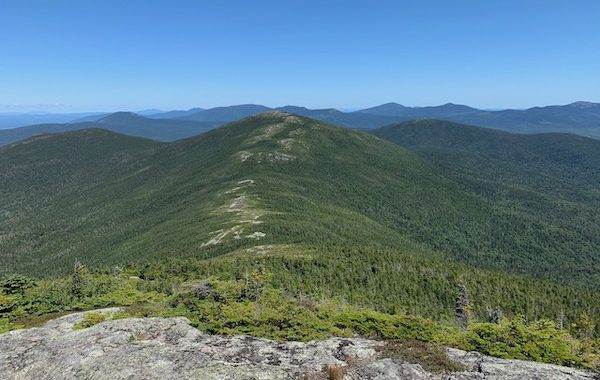
Show your support for MATC by proudly wearing and displaying official clothing and accessories emblazoned with the MATC logo. Check out the variety of MATC branded items at our “Trading Post” – on-line store.
MATC has partnered with Spreadshirt to provide MATC branded clothing and accessories to members and supporters of the Maine Appalachian Trail Club. Items are available in a variety of styles and colors.
MATC Branded Items from Spreadshirt.com – Many more styles and items available at the store
MATC is a non-profit, 501c3 charitable organization and does not make any profit on these items. Spreadshirt is a third-party, affiliated vendor who handles all sales and questions regarding their products.
We encourage the owners of the Saddleback Ski Area (Arctaris Impact Fund) to move the location of its proposed grid-scale solar power generating facility to a location that would not impact the views from the Appalachian Trail (A.T.) on Saddleback Mountain. At just over three miles away, the proposed 35-acre solar array would become the dominant feature on the landscape view looking north from the A.T.
Other than Katahdin, Saddleback offers the longest open ridge walk along the A.T. in Maine and about 1.5 miles of this section would have frequent views of the solar development. Given the facility’s high contrast and reflective panels tilted towards the mountain, the array would draw visitors eyes towards them and create a negative impact on what is now a natural view of lakes, forests and mountains.
Saddleback Ski’s stated objectives to move off fossil fuel and source with 100% solar electricity are admirable. We believe Saddleback Ski can reduce its carbon footprint and lower its electricity costs through a less impactful alternative:
The Maine Appalachian Trail Club (MATC) and the Appalachian Trail Conservancy (ATC) hold the position that development must be balanced against the recreational, scenic, natural and cultural resources of the Appalachian Trail (A.T.). As stewards of the A.T. in Maine, part of MATC’s mission is to preserve the scenic integrity and minimize development impacts adjacent to the A.T.
Both the ATC and MATC support Saddleback Ski moving to 100% solar-sourced electricity and encourage them to seek alternatives that would have less impact on the views for the visitors to the Appalachian Trail and Saddleback Mountain.
It’s fall. That time of year with crisp air, shorter daylight hours, crunchy apples… and what else? Falling leaves! This vibrant foliage settles in voluminous quantities onto the ground in our yards. And the A.T. isn’t immune to this annual jettison of foliage either. But on the A.T. it can create problems with water drainages if not addressed. When it rains the leaves wash into these drainages where they often accumulate in the narrow or flatter locales, essentially damming the flow of water. Where’s the water to go now? In the trail! Water is ruthless and will find its way around and over obstacles if its designed flow path is interrupted, and either erode the trail, create a mud hole, or perhaps ruin the drainage structure itself. What’s a trail maintainer to do? Grab your favorite hoe and go for a nice walk on your trail section, combing the drainages and their outflows of leaves. Don’t think you are out of the woods if your trail section is mostly non-deciduous trees. Needles shed from softwood trees can cause the same issues! It’s a great time of year to be in the woods, so please consider purging your drainages of leaves, and needles, to keep water off the trail!
Trail before drainage cleaned- muddy…Drainage full of needles and leavesDrainage after it was raked out. Trail after drainage cleaned- no more pooled water!
We have some BIG news to share. One of the Appalachian Trail’s most iconic stretches is now permanently protected.
Cold, clear Bald Mountain Pond in Northern Maine welcomes paddlers and anglers from across the country. Hikers on the Appalachian Trail skirt the far shore, threading through century-old forests, taking in views of Mount Katahdin, and bedding down for a night in the sturdy hikers’ shelter just a few steps from the pond’s banks. Many thru-hikers even call reaching this spot the highlight of their journey.
Photo by Chris Bennett, courtesy of The Trust for Public Land
The timber companies that once owned the pond and the surrounding forest historically allowed recreational access to the area—but that arrangement was more of a tradition than a guarantee.
Photo by Chris Bennett, courtesy of The Trust for Public Land
When a once-in-a-lifetime opportunity emerged to protect this extraordinary place, we teamed up with more than a dozen partners to permanently open access to this spectacular stretch of the Appalachian Trail. Now, a locked gate will never stop future visitors. The 2,620 acres surrounding Bald Mountain Pond’s rugged shoreline, and an iconic stretch of the Appalachian Trail, will remain protected from development and open to the public forever.
Book and 7 maps: $24.00 MATC Members (20% discount) $30.00 Non-members
Book with no maps: $12.00 MATC Members. (20% discount) $15.00 Non-members
The Maine edition covers 282 miles from Katahdin in Baxter State Park to the New Hampshire state line in one planning guide and seven water- and tear-resistant maps. The pocket-sized planning guide contains background information, points of interest, and road-access directions. Each map is focused on the Appalachian Trail and overlaps with the neighboring maps. The surrounding area and additional side trails are also included. An easy-to-use elevation profile shows the ups and downs and the distance to the next campsite or shelter, side trails, and water sources. For added interest, maps indicate road crossings, waterfalls, and scenic areas. Maps are both water- and tear-resistant.
Map 1: Katahdin to South End of Nahmakanta Lake Published by the Maine Appalachian Trail Club. Four-color, 1:62,500-scale topographic maps with 50 feet contour intervals. Revised in 2009.
Map 2: Nahmakanta Lake to West Branch of the Pleasant River Published by the Maine Appalachian Trail Club. Four-color, 1:62,500-scale topographic maps with 50 feet contour intervals. Revised in 2009.
Map 3: West Branch of the Pleasant River to Monson Published by the Maine Appalachian Trail Club. Four-color, 1:62,500-scale topographic maps with 50 feet contour intervals. Revised in 2009.
Map 4: Monson to the Kennebec River Published by the Maine Appalachian Trail Club. Four-color, 1:62,500-scale topographic maps with 50 feet contour intervals. Revised in 2009.
Map 5: Kennebec River to Maine Highway 27 Published by the Maine Appalachian Trail Club. Four-color, 1:62,500-scale topographic maps with 50 feet contour intervals. Revised in 2009.
Map 6: Maine Highway 27 to Maine Highway 17 Published by the Maine Appalachian Trail Club. Four-color, 1:62,500-scale topographic maps with 50 feet contour intervals. Revised in 2009.
Map 7: Maine Highway 17 to Maine/New Hampshire State Line Published by the Maine Appalachian Trail Club. Four-color, 1:62,500-scale topographic maps with 50 feet contour intervals. Revised in 2009.
Maps can also be ordered individually under the Maps tab above.
Shipping and handling (with or without maps): $6.00 for 1 copy $10.00 for 2-6 copies
Did you observe a maintenance or issue on trail while hiking the AT in Maine?
Please send MATC a Trail Report providing details and a photo if available regarding an issue or maintenance need on the Maine AT. We will send your report on to our district managers.
ATC’s blog post from July 28 tells the story of a day in the life of an A.T. volunteer; getting up early on a day off to move rocks, cut brush, and swat bugs. All for a whopping paycheck with lots of zeros, including a leading zero… But the rewards are tremendous and have lasting impacts. Featured in the ATC blog post is MATC legend Dave Field; he’s been maintaining and protecting the A.T. for over 50 years! Be sure to scroll down the page to read about Dave, and watch the “myATstory” short film on his lifetime of efforts!